Monday, December 10, 2012

November 27th - Mitochondrial Eve

Mitochondrial Eve

Mitochondrial Eve is the maternal ancestor of all living humans that lived 200,000 years ago. All humans carry mitochondrial DNA that can be traced back to this single woman. The discovery of Mitochondrial Eve has changed the way we view evolution.


source: http://io9.com/5878996/how-mitochondrial-eve-connected-all-humanity-and-rewrote-human-evolution


African descent
Asian descent


Scandinavian


Irish descent
European

November 13th - Plant blog


November 13th - Plant growth

Day 1:


Week 2:


Week 3:


Week 4:


October 30th - Cemetery Blog

Col. John Basil Lamar

Among several notable people buried in Rose Hill Cemetery is Col. John Basil Lamar who died on September 15, 1862. Col. Lamar, born in Milledgeville on November 5, 1812, attended UGA in 1827, but moved to Macon in 1830. In 1837 and 1838, Lamar served in the Georgia House of Representatives and, then, in 1842, he continued on to serve Georgia in the US House of Representatives during the 28th Congress. He resigned from office in 1843 and returned to life in Georgia, where he became master of a great cotton planting empire that included 14 counties and the state of Florida. He served on the UGA Board of Trustees from 1855 until 1858 and then, in 1861, served at the state convention that passed the Ordinance of Secession. Lamar was also known as a great writer of the South. Lamar served during the Civil War as an aide to Confederate General Howell Cobb, his brother-in-law. He was wounded during Battle of Crampton's Gap in Maryland and died the next day. He was originally buried in Charles Town, Virginia and then, later, reinterred in Rose Hill.


source: http://txgenelady.com/LamarFamily/LamarBios.html

Tuesday, October 30, 2012

October 23rd - Ocmulgee National Monument

October 23 - Ocmulgee Indian Mounds lab

History of the Ocmulgee National Monument:


President Roosevelt established the Ocmulgee National Monument in 1936 in order to preserve the enormous Indian mounds on site in Macon, Ga. There are seven mounds in the area, including but not limited to: the Greater Temple Mound, the Lesser Temple Mound, the Funeral Mound, and the Earth Lodge.


funeral mound

Unearthed skeletons and artifacts from the Funeral mound indicate that the earliest inhabitants of Ocmulgee practiced intentional skull modification. This is in concordance with a Creek migration legend explaining the nature of the people that the Creek's massacred. This also indicates that the mounds were already inhabited by a different group of people when the Muscogee Creeks arrived.


The Muscogee Creek Indians are only credited with building the Earth Lodge, all other structures were in existence before they inhabited the area. The Earth Lodge includes space for 50 to be seated with three seats in the center for tribal leaders or other elders of importance. It is evident that all of the structures at the Ocmulgee National Monument originate from two different peoples who lived in the area at two different times.


This is what the mounds are believed to have looked like in 1000AD. The Ocmulgee Mounds is the site of one of the largest Native American cities in the US and is home to the tallest earthen pyramid, one in a set of seven that were built and constructed around 800AD. The tallest, the Great Temple Mound, stands at 56 feet above ground, but, from the base of the plateau to the top of the mound, it is actually over 90 feet. It is believed that a temple and/or chief's residence resided at the top of the mound.


An aerial view of the construction of the railroad in 1847 that destroyed parts of the lower mounds.


A picture of the excavation of the Ocmulgee Indian mounds 


Another photo of the excavation of the Ocmulgee Indian Mounds


source: http://www.examiner.com/article/quest-for-georgia-s-native-americans-part-2-macon-georgia

Tuesday, October 23, 2012

Oct 9th and Oct 16th - Rocks and Minerals lab and Soil lab combined

Oct 9 - Rocks and Minerals lab

1. Igneous rock: Granite


Granite rock is made up of feldspar and quartz with small amounts of mica and amphibole minerals and is formed from the slow crystallization of magma below the earth's surface. It has a chemical makeup of mostly SiO2 and Al2O3. Two famous places it can be found are: Stone Mountain in Georgia and Mount Rushmore in South Dakota.


link: http://geology.com/rocks/granite.shtml


2. Metamorphic rock: Gneiss


Gneiss rock is made up of quart and feldspar that were originally part of an igneous rock that has been modified by heat, pressure, and chemical processes while buried under the earth's surface. 
Gneisses can also contain mica minerals and aluminous or ferromagnesian silicates. Gneiss is commonly found in the northern United States.


link: http://geology.com/rocks/gneiss.shtml


3. Sedimentary rock: Shale


Shale rock is a fine-grained sedimentary rock formed from the compacting of mud, or silt and clay-sized mineral particles. Shale can be composed of illite, kaolinite, smectite, quartz, chert, and feldspar. Shale can be found in New York, Alabama, Texas, Michigan, Oklahoma, Arkansas, Colorado, Louisiana, Illinois, etc.


link: http://geology.com/rocks/shale.shtml


Oct 16th - Soil lab


Soil texture diagram:


image from: http://www.jsu.edu/dept/geography/mhill/phylabtwo/lab12/soiltextdiag.jpg


Munsell soil color chart:


image from: http://soilslab.cfr.washington.edu/esrm210/10_01_08.html


The Twelve Soil Orders
Alfisols, Andisols, Aridisols, Entisols, Gelisols, Histosols, Inceptisols, Mollisols, Oxisols, Spodosols, Ultisols, Vertisols


General soil type for Georgia:
Ultisol (red clay) is the most common type of soil in Georgia.

Tuesday, October 2, 2012

September 25th - Trees, Shrubs, and Flowers lab

In this lab, we went on a walk around campus and identified various types of trees, shrubs, and flowers.  Here is our path:


Trees:
1) Crape Myrtle trees or Lagostroemia:
Crape Myrtles prefer warmer climates and they are know for their colorful and long-lasting flowers. The bark of a Crape Myrtle also sheds throughout the year, giving the tree a mottled appearance.


2) Pecan trees or Carya illinoinensis:
A Pecan tree is a large deciduous tree and a species of hickory. It is known for the pecans that it produces which are technically drupes, a fruit with a single stone pit.


3) Southern Magnolia trees or Magnolia grandiflora:
Southern Magnolia trees are native to the southeastern United States. It is a medium to large evergreen tree that produces large white, fragrant flowers.


Shrubs:
1) Loropetalum bush or Loropetalum chinense:
The Loropetalum bush is an evergreen bush that enjoys the sun.


2) American Holly bush or Ilex Opaca:
A holly bush has pointy leaves and berries and is part of a genus that includes 400 to 600 species of flowering plants.

3) Poison Ivy or Toxicodendron radicans:
Poison Ivy is a poisonous North American shrub that is known for its production of Urushiol that causes irritation and rashes. It is not true ivy.


Flowers:
1) Daylillies or Hemerocallis:
Daylillies are perennial plants. The flowers usually do not last longer than 24 hours, with new flowers opening every day.


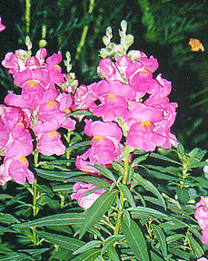
2) Snapdragons or Antirrhinum:
Snapdragons are perennial plants that do well in sunlight.


3) Marigolds or Tagetes
The blooms of this flowering plant can be golden, orange, yellow, or white, often with maroon highlights.


September 11th - Ocmulgee River Lab (Elevation, Clams, and Flow Rate)

During our lab at the Ocmulgee River (image below), we took measurements to determine the elevation of the river, we took samples of clams to see where in the river clams preferred to burrow, and we calculated the flow rate of the river in three places. 

Here is a Google Earth image of where we worked and took measurements. The pink transect line is the line on which we took elevation measurements and the three pointers indicate where we dug for clams.


1) Determining the Elevation: 
We used measurements from two poles connected by a string to gather the changes in elevation along the river bed. The string between the poles had a "line level" on it to indicate when the string was flat and the two poles had matching gradations (0, 1, 2, 3, 4, 5, 6) that the string lined up to. The distance between the poles at all times was 10ft. The change in elevation was reflected by how many gradations the string was different on either pole. We calculated the elevation by subtracting the first pole's number from the second's and uphill was signified by a negative number. Here is the graph of the elevation of the Ocmulgee River:


2) Clam Samples:
After the elevational measurements, we took samples of sand from near the river bank and then sand from the river channel and tried to determine where in the river clams prefer to live. We took numerous sample collections by digging up sand and placing it in a sifter. After running water over the contraption to get the sand out, only clams, rocks, and other debris too big to pass through the material were left. Out of all of our samples, clams were more abundant in the actual river channel as opposed to the sand, so we determined that clams prefer to live in the river channel. 

3) Flow rate:
The last experiment we did at the river was determining the flow rate of the water. To do this, we set up a group of people in two different points along the river. The group upstream had an old plastic water bottle and dropped it in the water and signaled the other group to begin timing. Once the bottle reached the downstream group, they stopped the timer. To calculate the flow rate, we used this experiment and the equation: DISTANCE/TIME.


Tuesday, September 4, 2012

September 4th - Maps Lab Assignment

1.


A chloropleth map is a thematic map on which different areas are color-coded, shaded, or patterned in proportion to the measurement of the statistical variable being displayed on the map. In this example, the variable would be population change. This example indicates that Nevada has had the biggest population change between 1990 and 2000.


2.

A dot density map is a map that uses a dot or symbol to indicated the presence of a feature or phenomenon within certain boundaries. It does not matter where the dot/symbol goes in the boundaried area. There is always a numerical value associated with the dot. This map indicates that nonmetro poor are present in bigger numbers in the eastern states.


3.


A proportional symbol map is a map in which the areas of symbols are varied in proportion to the value of an attribute. Each symbol varies in size according to its value. In this example, each disc indicated how many Walmarts are in that specific state.


4.
 
An isopleth map is a map that uses lines with different values to delineate boundaries. The map consists of contour lines that depict a variable which must be calculated from data collected over an area. Isopleth maps are used in weather and to indicate how steep certain terrains are.


Severe weather link (abc Action News): 
http://abclocal.go.com/wpvi/story?section=news/local&id=8787041